TISA® 3D Borehole Radar project

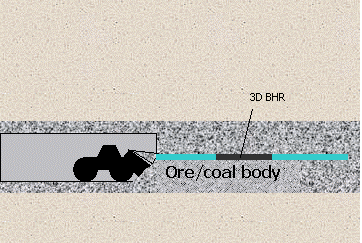
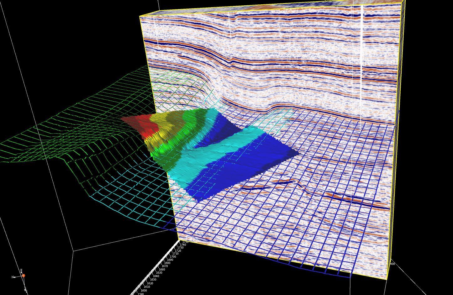
The TISA 3D Borehole Radar is a geophysical technique for high-resolution 3D mapping of the surroundings of a borehole. Applied in a single borehole, this technique combines all the advantages of GPR tools in one piece of equipment: high-resolution data with directional information and a penetration range of up to 15 meters.

TISA 3D is a breakthrough technology as it is the first tool to allow radar survey at greater depths, with very high accuracy and in difficult circumstances. T&A was responsible for the system design, engineering, the operating and processing software and testing. Subcontractor TNO-D&V (Defense and Safety) developed the radar electronic component of the downhole probe.

Development in 2 phases

The development of the TISA 3D Borehole Radar consists of two phases. Phase 1, the development of the TISA 3D prototype for the detection of metal objects in boreholes up to a depth of 100 meters, was successfully completed and tested. T&A will now proceed to phase 2: The development of the full service tool for use in boreholes up to a depth of 4.000 meters for the characterization of oil and gas reservoirs


TISA 3D technology has the following advantages over existing tools and methods:       

  • TISA 3D can image structures tens of meters away from the wellbore - TISA 3D images up to 15 m into the formation with a resolution of 0.017- 2 m, depending on the antenna type. In highly resistive environments such as pure salt bodies, radar signal will actually penetrate for hundreds of meters.      
  • Scalability - Due to its modular nature, parts of the TISA 3D tool can be interchanged flexibly. Modules such as source and receiver antenna, communications and power can be adjusted to the application (shallow/deep, wireline/MWD). Depending on the resolution and distance of the target form the borehole various antenna frequencies are possible. 
  • A complete image of the borehole surroundings -  Compared to other borehole tools, the 3D nature of the TISA 3D measurements add an extra dimension to the target. Fractures and their networks are imaged, together with the fluids flowing through them and the steam/water fronts.       
  • Operation of the tool in various borehole conditions - The TISA 3D technology has no adherence to a specific type of drilling fluid (water-based, oil-based or synthetic) and can actually measure the degree of mud invasion in the formation. Hardening of the tool for high pressure and temperature conditions will be comparable to other borehole tools. Radar measurements are not hindered by the mechanical noise due to high pressure and vibrations.

The TISA 3D Borehole Radar technology is a promising addition to existing logging techniques in oil and gas exploration and production.More accurate reservoir assessment leads to less reservoir uncertainty, lower technical and financial production risks and improved reservoir management. Surface systems usually do not have sufficient penetration and/or resolution to create a clear view of oil and gas reservoirs. Currently no techniques exist that can map the environment of a borehole three-dimensionally.

The TISA 3D will be the first technique capable of collecting high resolution data from the borehole environment and not only from the direct borehole wall.

Main applications of TISA 3D in E&P

  • Logging tool: In an exploration environment, TISA 3D can be used as an Electric Propagation Tool to detect the electrical properties of the formation.
  • Geosteering: In thin pay zones, where it is crucial to follow a specific drilling path,  TISA 3D can provide the information to steer the drill bit. The distance to the top and bottom of the reservoir can also be measured.
  • Monitoring: In production phases, where water or steam drives are used, the TISA 3D is well suited to monitor the movement of the steam/water front in 3D.

Reservoir penetration range

The penetration range of the TISA 3D system in reservoirs is 5 to 10 meters, based on average reservoir properties (see table). Penetration range increases with increasing resistivity. In ideal situations, a penetration range of 15 meters can be obtained.


The mining industry is all about knowing what's going on in the underground. Without subsurface testing, it is impossible to locate an ore body, to define exploitable reserves or to design a mine plan.

Geophysical tools used in the oil industry (such as 3D seismic techniques) have been adapted and applied in mining industry, resulting in great benefits for the exploration of mines. However useful these tools may be, none of them can compete with the TISA 3D Borehole Radar’s capacity to reveal a high-resolution contrast between different materials in the underground.

Applications TISA 3D in Mining

  • detection of lateral and vertical heterogeneities
  • detection of cavities, faults and fracture zones
  • locating ore bodies
  • determining exploitable reserves
  • designing a mining plan
  • detection of pot holes

In order for a geothermal project to be successful, it is important to study the geological structure and stratigraphy of the subsurface of the planned location. The research target of a geological study is to map deep groundwater reservoirs or acquifer. The groundwater reservoir needs to be estimated very accurately prior to making the decision whether a geothermal system can be successfully and economically exploited.

Application of the TISA 3D for the detection of geothermal energy

  • Defining the location and dimensions of the acquifer.
  • Determining the presence of an impermeable coating on top of the acquifer.
  • Detecting cracks and fractures.


After many years, the exact location of structures (concrete piles, sheet piles and foundations) is often unknown and needs to be determined again. Geotechnical investigation of underground structures aims to determine the exact location and dimensions of a structure or to check for possible damage or decay. Research from ground level is often difficult because the structures are too deep or in a densely built environment. TISA 3D can offer a solution.

Steered Drilling

Steered drilling is a new technique for laying underground cables. As an alternative to digging trenches, it is a cost-effective method that causes fewer disturbances to the environment. As the number of cables and other objects in the shallow subsurface increases, there is more need for exploration of the drilling path. As an alternative to measurements from the surface, the high-resolution directional borehole radar can be integrated in the drilling process to explore the drilling path in advance.


Jet grout injections consolidate the soil and decrease the risks of subsidence from large surface structures. Jet grout columns vary in diameter, depending upon the injection pressure and the soil conditions. The diameter is an important property that should be quantified, especially when several grout columns are connected to form an underground concrete floor. Until now, no proven or tested techniques existed to calculate the diameter ofinjected columns. Until now, it has been almost impossible to conclude whether thejetgrout foundations provide enough stability, especially in underpinning applications.

Applications of TISA 3D in jet grouting

By integrating the TISA 3D Borehole Radar technology into the injection lance, the diameter of the column can be determined on site. The boundary between grout column and hosting medium is a sharp edge and, therefore, a good reflector for incident radar waves.

There are two ways to apply the TISA 3D in the jet grouting process. In both cases, the diameter can be measured very precisely because of the resolution of the TISA 3D method:
  1. Integrating the TISA 3D in the jet grouting system. During construction of the column, the radar is located just below the injection point and the grout column diameter is measured from within the column. The injection pressure can be adjusted while the column is being made.
  2. Drilling a borehole near the grout column allows the TISA 3D to measure the distance from this borehole to the edge of the column.


It is essential that any tunnel project starts with a comprehensive investigation of ground conditions. In addition, encountering unforeseen ground conditions, objects or anomalies can be costly in terms of time and materials. The TISA 3D Borehole Radar technique continuously gathers detailed information about obstacles and geological transition zones.

Applications TISA 3D in tunnel track exploration

TISA 3D is positioned in a horizontal borehole with a diameter of about 20 centimeters, and drilled along the planned trajectory. It measures the complete surroundings of the borehole. Rotating 360°, it gathers and processes data from all angles with special proprietary software. After processing, the raw ground penetrating radar data is combined with simultaneously collected positioning data, providing meaningful operating data.


WWII Unexploded ordnance (UXO) detection from the surface is often not feasible, since the explosives are buried too deep. When a bomb dropped from an airplane doesn't explode touching the surface, it penetrates the upper soft peat and clay layer and stops at the first stable sand layer. In the Netherlands, this layer can be located at a depth of more than 10 meters below the surface. Due to resolution problems, detection from the surface is not an option in these cases. Measurements from a borehole are needed to solve the problem. Traditionally, these measurements are done using a magnetometer.

Applications TISA 3D in UXO detection

UXO with a large metal content show a strong electrical contrast with the surrounding soil. Therefore, these objects are very good reflectors of radar waves. For TISA 3D Borehole Radar measurements, a borehole is drilled in a safe zone, just outside the investigation area. When it's determined that the area around this borehole is safe, the next measurement is done in an adjacent position closer to the area of investigation. This way the whole area is searched for deep explosives.