Technologies & sensors

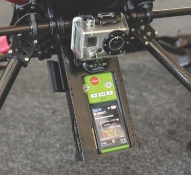
T&A has a wide range of sensors and geophysical techniques in house that can be attached to our drones in order to perform a survey. This way we can offer our clients the best configuration for every project.


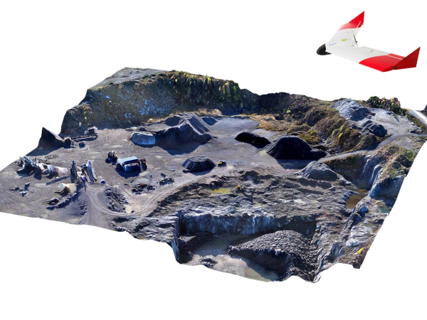
Photogrammetry is the creation of maps from digital aerial photographs which have been made with special high-resolution cameras.

How does Drone Photogrammetry work?

By attaching lightweight photo cameras to drones, high-resolution digital 3D aerial photos can be generated, which can then be processed with special software.

This technology can be used for many different purposes:
  • creating maps
  • gathering geo-information 
  • digital aerial photographs
  • digital orthophotographs
  • 3D relief models
  • high density point clouds
  • ortho mosaics

Application

These 3D spatial data of (objects on) the earth's surface can be used to calculate distances, surfaces and volumes. The current technology allows us to make elevation models with a resolution and vertical precision of better than a few centimeters.


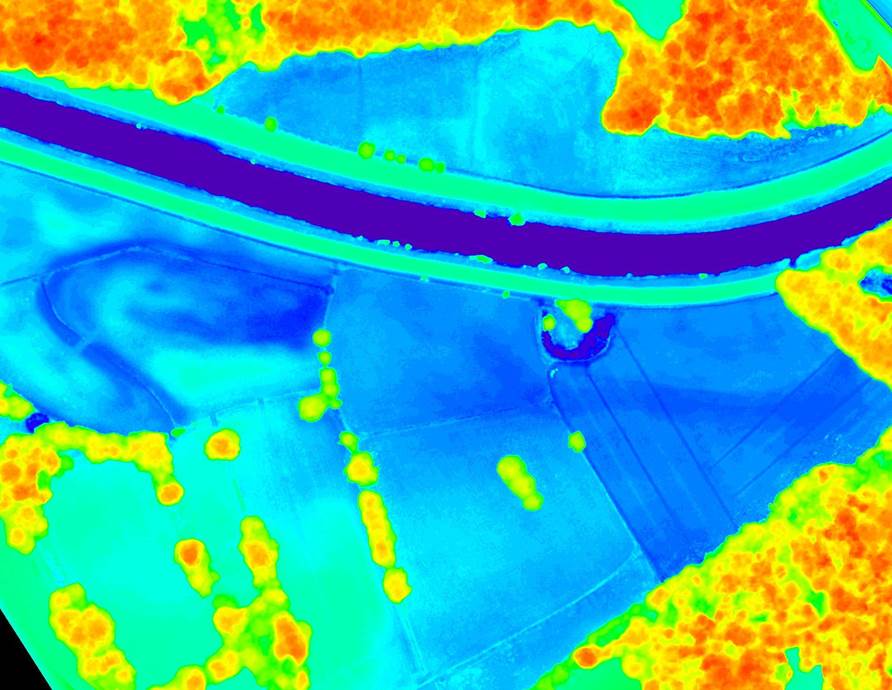
Infrared (IR) thermography is a no-contact technique for measuring the surface temperature of a body or an object. This is done with an infrared camera.

How does it work?

An IR thermography camera produces a thermogram, a visual representation of the temperatures of the object, with different colours representing different temperature ranges. In most cases low temperatures are represented by dark colours and high temperatures by lighter ones.

The best results are achieved in cases with temperature differences of at least 10 degrees Celsius between the object and its environment. This makes winter the most suitable season for drone IR thermography in the open air.

Applications of Drone IR thermography

  • Protect and monitor
  • Locating fires
  • Detecting heat leaks and overheating on high voltage pylons or power plants
  • Detecting weak spots in dikes
  • Detecting underground artifacts and structures (archeology)
  • Wildlife counts in nature reserves

How does IR spectrometry work?

Drone IR spectrometry measures the infrared absorption of an object. By determining which frequencies have been absorbed, it is possible to determine which chemical bonds occur in the measuring object. The percentage of light reflected from the measurement object is displayed as a graph, called an infrared spectrum. An infrared spectrum is a representation of the frequencies of the absorbed infrared light. By using this spectrum it is possible to analyze which chemical compounds occur in the object of investigation.

Application of Drone IR spectometry

  • Oil and gas exploration
  • Mining
  • Environmental research: determining the chemical composition of ore deposits, reservoir rocks and substances that pollute the soil
  • Agriculture: early detection of crop diseases
The Laser imaging Detecting And Ranging (LiDAR) technology uses laser pulses to determine the distance to an object. The technology is comparable to radar, but where radar uses radar waves, LiDAR uses light waves. Since the wavelength of laser light is much shorter than radar waves, LiDAR is able to detect much smaller object. Also, its short wave length makes LiDAR relatively insensitive to surface vegetation.

How does LiDAR work?

LiDAR works according to the same prinicples as radar: a transmitted laser beam is reflected by an object and after a while returns to receiver. The speed of the laser beam and the time span between transmission and reception determine the distance to te object. Since the laser beam stays strongly bundled, it's possible to make a surface or relief scan of an object or area by gathering data from different angles. The velocity is determined with the Doppler effect.

Applications of drone LiDAR

  • Calculate vegetation density
  • Measuring CO2 storage (primeval) forest
  • Detect overgrown structures/ruins in impassable, densely wooded areas.
  • 3D elevation models of areas with dense vegetation,
  • Speed measurements
  • Monitoring the thickness of polar ice caps and glaciers.

The Height Technologies (HT) G3 LiDAR/RGB packet offers a drone with integrated LiDAR technology  Find out more.

 
A Corona camera shows the corona discharge caused by damaged insulation materials protecting for example high voltage switches or wires. Failure of insulation materials can lead to discharge failures causing damage to the implant, a break down of the power supply and possibly even fires and explosions.

Drone inspections with a Corona cameras can be done without shutting down the power line, which has considerable advantages in terms of costs, risk and time compared to inspections performed by people.

How does Drone Corona Camera work?

A corona camera  shows the UV light generated when nitrogen comes into contact with a power leak. As "normal" ultra violet light is filtered out, corona can be visualised even in broad daylight. During the measurements a normal video image and the UV source are shown simultaneously, making it easy to locate the corona accurately.

There is a high demand for an easy and cost-efficient method for the detection of methane in all sectors of the natural gas industry. The measurement principle of the drone methane detector uses the characteristics of methane, which absorbs laser beams (infrared rays) of a specific wavelength, called infrared absorption technology.

How does the drone methane detector work?

The laser beam directed at targets such as the ground or gas piping, will reflect back a diffused beam from the target. The device will receive the reflected beam and will measure the absorption of the beam, which will then be calculated into methane column density (ppm-m). Due to the fast spreading of methane outside the leak, the best results are obtained in calm weather.


With the Drone magnetometer and gradiometer, ferrous objects and soil layers can be detected from the air. Although still in the development phase, the drone magnetometer system has been successfully used in several (international) projects.

How does it work?

The magnetometer and the gradiometer measure the earth's magnetic field. This field varies due to local deviations such as ore deposits or ferrous objects such as UXO. By measuring this local deviation from the total magnetic field, the location of ferrous objects and soil layers can be determined. The gradiometer is a magnetometer which measures the change in the magnetic field (the gradient of the field). Compared to a magnetometer this increases the measurement accuracy and the sensitivity to regional changes of the Earth's magnetic field. Both measuring systems can also be used on the water.

Applications of drone magnetometer


*Drone magnetometer is currently under development.

Ground Penetrating Radar (GPR) is an electromagnetic reflection technique. It is able to quickly, accurately map the first few meters of the underground from the surface or just above. GPR has high accuracy and is mainly used to locate objects or layers.

For optimal results the GPR equipment needs to be moved as close to the surface as possible. The maximum penetration, depending on the soil composition, is approximately 1.5 m.

How does Drone GPR work?

GPR uses electromagnetic waves sent into the ground or object by a transmitter antenna. The waves are being reflected if there is a change in material properties of the ground or construction. The reflected waves are registered by a receiver antenna. The measurement results are analysed to determine the horizontal and vertical position and the dimensions of objects and/or layers.


* Drone GPR is currently under development.

EM (Electro Magnetic) induction or Radio EM is a technique which determines the electrical conductivity of the underground in a non-destructive way. Metal objects like UXO (ferrous and non-ferrous), cables and pipelines, conductive soil layers and fracture zones in the underground can be detected with this geophysical technique.

How does Drone EM induction work?

The electromagnetic (EM) field is sent into the ground by a transmission coil. In conductive objects or layers this inducted EM-field is larger and of longer duration compared to the less conductive surrounding material. To detect conductive objects, peak values in the registered data are analysed according to their horizontal and vertical position, approximate dimensions of the conductive object and signal strength.

* EM detection with drones is still in the development phase.